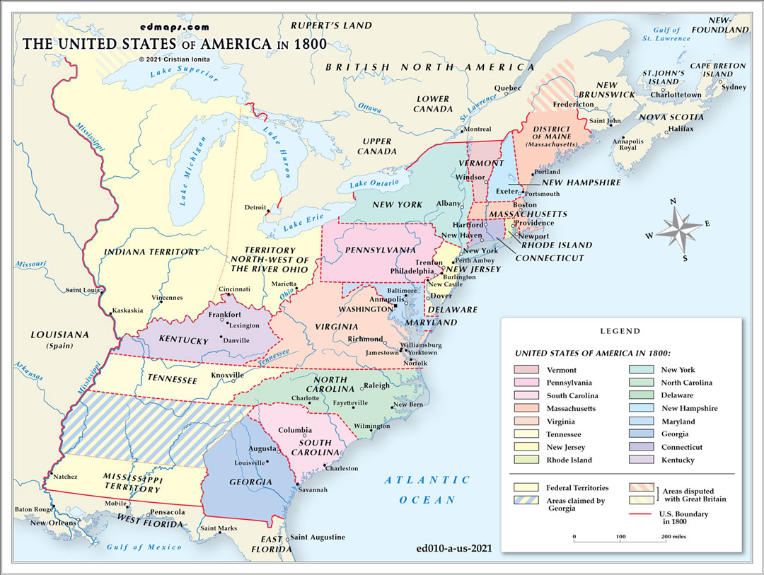
By 1800, the United States had expanded to sixteen states with several organized territories, reflecting significant territorial growth and administrative development during the 1790s.
The nation comprised sixteen states following Kentucky's admission in 1792 and Tennessee's in 1796. This expansion demonstrated the Constitution's effectiveness in managing territorial growth while maintaining sectional balance between free and slave states.
The Northwest Territory remained the largest federal territory, though Ohio was approaching statehood requirements by 1800. The Indiana Territory was carved from the Northwest Territory in 1800, with William Henry Harrison as territorial governor, encompassing present-day Indiana, Illinois, Wisconsin, and parts of Michigan and Minnesota.
The Mississippi Territory, created in 1798 from lands disputed with Spain, included present-day Mississippi and Alabama. This territory resulted from Pinckney's Treaty (1795), which resolved boundary disputes with Spain and secured American navigation rights on the Mississippi River.
The Louisiana Purchase negotiations were underway but not yet completed, leaving vast western lands under foreign control. Spain still controlled Florida and had recently retroceded Louisiana to France, creating uncertainty about western boundaries.
Under Federalist leadership, territorial administration became more systematized. The federal government exercised direct control over territorial governance through appointed governors and judges, while territories progressed toward statehood following the Northwest Ordinance model.
Several boundary disputes were resolved during the 1790s. The Treaty of San Lorenzo (1795) settled the southern boundary with Spanish Florida at the 31st parallel. However, Georgia's western land claims remained contentious, leading to the Yazoo Land controversy.
Native American nations continued controlling substantial territories, particularly in the Great Lakes region and Southeast, where tribes like the Cherokee, Creek, and Iroquois maintained semi-autonomous status despite increasing American pressure.
Sources, Methodology & Educational Use: The maps presented on this page are original creations produced for edmaps.com by Dr. Cristian Ionita. Each map is based on verified historical data relating to the territorial evolution, administrative structures, and political history of the United States. The maps are designed according to established practices in historical cartography, including source analysis, period contextualization, and visual clarity. The collection is curated to support teaching, learning, and public understanding of the U.S. history, and is intended for educational and non‑commercial use.
edmaps.com — Historical Cartography for Education
edmaps.com provides original maps and curated historical maps designed to support teaching, learning, and public understanding of territorial evolution, political history, etc. The original maps are created by Dr. Cristian Ionita, and all curated maps are selected from public archives, historical collections, and private holdings, and are presented for educational and non‑commercial use.
© Cristian Ionita. All rights reserved.
Website: https://edmaps.com — Contact: info@edmaps.com