The Louisiana Purchase of 1803 presented unprecedented territorial challenges that fundamentally transformed American governance, expansion, and constitutional interpretation.
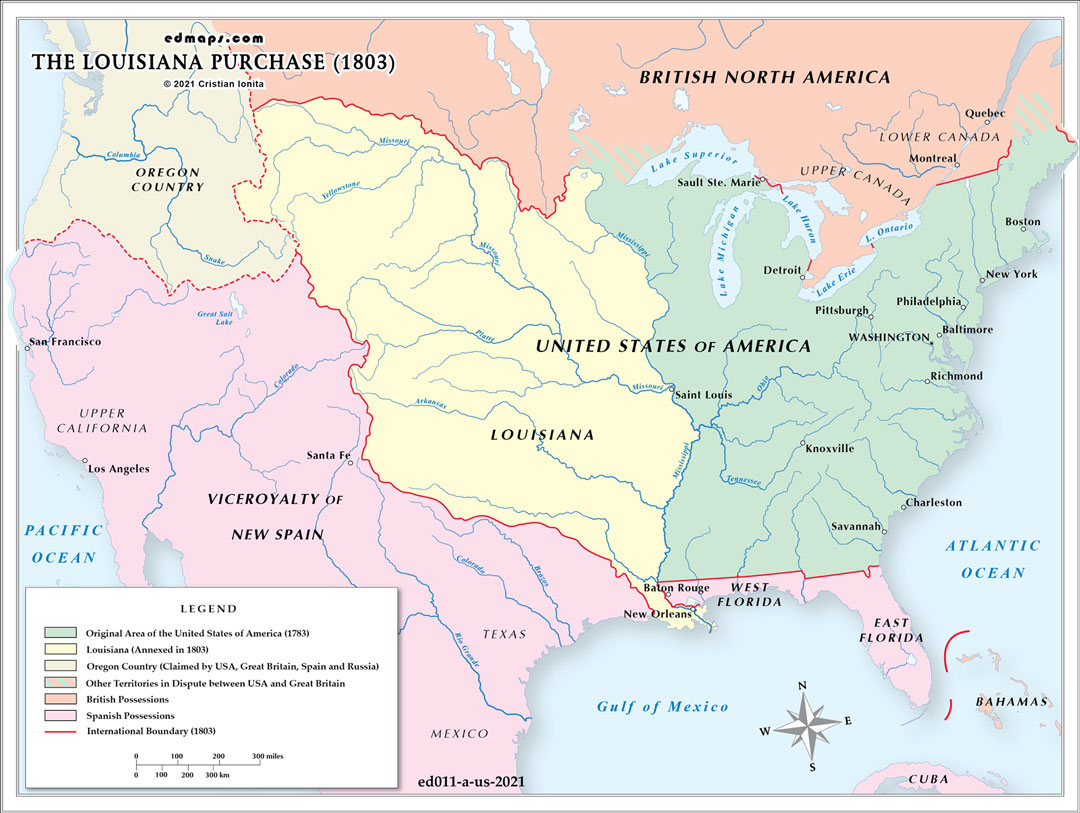
The acquisition doubled the nation's size, adding approximately 828,000 square miles of largely unexplored territory extending from the Mississippi River to the Rocky Mountains. This vast expanse required entirely new administrative frameworks, as existing territorial governance models were designed for much smaller regions. The federal government faced the monumental task of surveying, organizing, and governing territory larger than the entire existing United States.
The purchase raised profound constitutional issues about federal power. The Constitution contained no explicit provision for acquiring foreign territory, forcing President Jefferson to stretch implied powers despite his strict constructionist philosophy. This precedent expanded federal authority and established the principle that the United States could acquire territory through treaty negotiations.
The purchase initially created the Territory of Orleans (lower Louisiana) and the District of Louisiana (upper region). Managing these territories required balancing existing French and Spanish legal traditions with American law, accommodating diverse populations including French Creoles, Spanish colonists, free people of color, enslaved individuals, and numerous Native American tribes.
The acquisition intensified debates over slavery's expansion, foreshadowing future sectional conflicts. The purchase's vast size raised questions about whether new states would be slave or free, ultimately contributing to the Missouri Compromise crisis of 1820.
The purchase encompassed territories of dozens of Native American nations who had not consented to the transfer. This created ongoing conflicts over land rights, tribal sovereignty, and federal treaty obligations.
Control of New Orleans secured Mississippi River navigation, vital for western commerce. The purchase also provided agricultural potential, natural resources, and strategic buffer against British and Spanish territorial ambitions, fundamentally altering America's continental destiny.
Sources, Methodology & Educational Use: The maps presented on this page are original creations produced for edmaps.com by Dr. Cristian Ionita. Each map is based on verified historical data relating to the territorial evolution, administrative structures, and political history of the United States. The maps are designed according to established practices in historical cartography, including source analysis, period contextualization, and visual clarity. The collection is curated to support teaching, learning, and public understanding of the U.S. history, and is intended for educational and non‑commercial use.
edmaps.com — Historical Cartography for Education
edmaps.com provides original maps and curated historical maps designed to support teaching, learning, and public understanding of territorial evolution, political history, etc. The original maps are created by Dr. Cristian Ionita, and all curated maps are selected from public archives, historical collections, and private holdings, and are presented for educational and non‑commercial use.
© Cristian Ionita. All rights reserved.
Website: https://edmaps.com — Contact: info@edmaps.com