
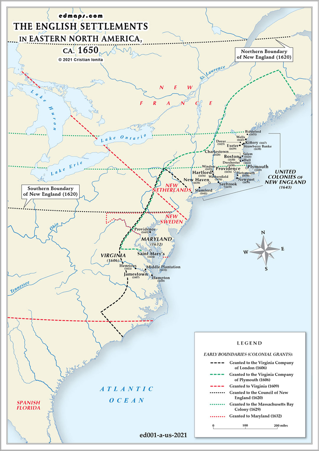
By 1650, English settlements in North America remained concentrated in relatively small coastal enclaves, representing the early foundation of what would become the thirteen colonies, though several future colonies had not yet been established.
Among the New England settlements, Massachusetts Bay Colony had expanded beyond its initial Boston settlement to encompass numerous towns throughout eastern Massachusetts, including Salem, Cambridge, Watertown, and Roxbury. The Connecticut River valley witnessed significant expansion with settlements at Hartford, Windsor, and Wethersfield forming Connecticut Colony in the 1630s. Plymouth Colony remained centered around Plymouth but had established several satellite communities. Rhode Island existed as scattered settlements around Providence and Newport, founded by religious dissenters like Roger Williams and Anne Hutchinson. New Hampshire comprised only a few coastal settlements around Portsmouth.
In the Chesapeake region, Virginia had evolved from Jamestown's precarious beginnings to encompass numerous tobacco plantations along the James, York, and Rappahannock rivers. Settlement extended roughly 50 miles inland, following river systems that provided transportation for tobacco exports. Maryland, founded in 1634, had established settlements around the Chesapeake Bay, particularly at St. Mary's City and along the Potomac River.
Several future colonies remained unestablished or barely existent. New York remained under Dutch control as New Amsterdam, centered on Manhattan Island and the Hudson River valley. Pennsylvania, Delaware, New Jersey, North Carolina, South Carolina, and Georgia did not yet exist as English colonies.
Total English colonial population approximated 50,000-75,000 people, concentrated in small farming communities and nascent commercial centers. Most settlements remained within 30 miles of navigable water, as overland transportation was extremely difficult. The western boundary of English settlement rarely exceeded 100 miles from the Atlantic coast.
Dense forests, Native American territories, and lack of transportation infrastructure severely limited inland expansion. Rivers provided the primary corridors for settlement extension, while the Appalachian Mountains remained a distant and largely unknown barrier.


Sources, Methodology & Educational Use: The maps presented on this page are original creations produced for edmaps.com by Dr. Cristian Ionita. Each map is based on verified historical data relating to the territorial evolution, administrative structures, and political history of the United States. The maps are designed according to established practices in historical cartography, including source analysis, period contextualization, and visual clarity. The collection is curated to support teaching, learning, and public understanding of the U.S. history, and is intended for educational and non‑commercial use.
edmaps.com — Historical Cartography for Education
edmaps.com provides original maps and curated historical maps designed to support teaching, learning, and public understanding of territorial evolution and administrative history. The original maps are created by Dr. Cristian Ionita, and all curated maps are selected from public archives, historical collections, and private holdings, and are presented for educational and non‑commercial use.
© Cristian Ionita. All rights reserved.
Website: https://edmaps.com — Contact: info@edmaps.com
